
SPECIAL WEATHER ANNOUNCEMENT 12/22-25
Posted on: December 20, 2022 - 12:38pm
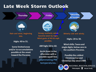
Here are the latest key messages for our region concerning the storm late this week:
- Late Thursday and Friday will bring periods of rain and increasingly strong winds. Wind gusts of 40-50 mph look probable Friday. Brief snow and/or freezing rain possible at the onset of precipitation Thursday, mainly toward the Poconos, where some limited accumulations could occur.
- Gale conditions are probable, with building, steep seas on the coastal waters and portions of Delaware Bay from late Thursday night through early Saturday. Minor coastal flooding is increasingly likely Friday morning, with spotty moderate flooding possible.
- There is some potential for a narrow squall line to accompany the arctic front Friday afternoon. This could be with little to no lightning, however it may transport stronger winds down to the surface.
- Very cold air will arrive later Friday and continue through the weekend. The holiday weekend will feature highs only in the 20s for much of the area, along with gusty winds and bitterly cold wind chills. If both the 24th and 25th had highs in the 20s, it would be coldest Christmas Eve and Christmas Day combination since 1989.
PLEASE MAKE SURE ALL JOB SITES ARE SECURED AND THAT ANY OUTDOOR FURNITURE AND/OR DECORATIONS AS WELL.